Friday, February 18, 2011

Adventures in Kansas, February; Part 3

Our short trip to Lawrence ended and it was time to go back home.

We took Highway 59 south out of Lawrence. Back in college days, when we used to go back to Lawrence after visiting family in Pretty Prairie, we would drive up 59 from Ottawa. We remembered it as a windy 2-lane with that spectacular view of "the hill" going into town. Now this road is in process of becoming a 4-lane highway between Ottawa and Lawrence.

As we got into Ottawa, we took another "off" road instead of the faster 4-lane highway to Emporia. We are aventuring, afterall! So we took a road we had not ever traveled on before. Highway 268 west. We would pick up highway 56 at Osage City.


There were signs saying this was also considered the Old Santa Fe Trail road. Not necessarily a road for those who get car sick. Hilly, twisty.
Very unusual names of roads along the way these 2 days of travel; Mormon Road, Jack Rabbit, North Pole Road, Chicken Creek, Gray Wolf, Robbers Roost. It was fun to wonder how they came up with those names.


Al kept commenting on animal tracks in the fields.


We may have encountered Indians.
We intersected Council Grove once again, but coming from the east this time, rather than from the south.


We kept going west on 56. Never been this way before.


We had to go to Hope. Two of the girs in our young married's group have connections here. Laura J. grew up here and her mom still does.
And Heather O. teaches at this school in Hope.


When we got to Highway 15, the rest of the way home was on road we had traveled before. Kansas is just beautiful!


As I was thinking about this road trip, it reminded me that we are traveling another kind of road. Our journey with Christ. Sometimes the journey can seem long. Sometimes it is breathtaking! There are uphills and downhills. Sometimes we can get lost along the way. Often we need Hope. The car needs refueling, just like we also need to be fueled up spiritually. It is good to have a map and we have that - the Bible that will guide and direct us in the way we should go. It is good to learn from others who have gone before us, like those pioneers. We can read about those faithful ones (and unfaithful ones) in the Word, but we can also read or learn from missionaries and other believers who can be such an encouragement to us. And just like those pioneers who would stop at the Last Chance store, there is a time for all of us to make the decision that will have an eternal impact. "For it is appointed to men to die once, and after this the judgment." Are we prepared for the journey?

Thursday, February 17, 2011

Kansas Adventures, February; Part 2

So, this was our destination.
Rock Chalk, Jayhawk, Go KU!
Taking the scenic side tour on the Sante Fe trail made the usual 2 1/2 hour drive to Lawrence, where Al went to pharmacy school, 4 1/2 hours! But what fun it was!
(In the olden days, it would have taken 3 days or more probably!)

When we got to Lawrence, we had to see our old stomping grounds....

our first home as young marrieds in 1975 - Stouffer Place, the married student housing.


The roof used to be flat but they added dormers and a pitched roofline.


Get a load of our plastic orange sofa!! Some apartments had green ones.

We had lots of snow in '76. (see the flat roof?)

Next, we took a look-see at the townhouse (Pinetree Townhouses) where we lived when we had Josh. Elaine Schmidt from church had this apartment before we moved there. Sam was a baby here too.


We checked into our hotel - The Oread. We had read about it in the "Kansas!" magazine that my Aunt Millie got for us (we are getting our travel ideas from this wonderful quarterly magazine!)


My mom wanted to know why it was called "The Oread". So, here is a little research, mom.

"Mount Oread sits on the water divide between the Kansas and Wakarusa rivers. It was named after the Oread Institute in Worcester, Massachusetts. The hill was originally called "Hogback Ridge" by many Lawrence residents until the Oread name was officially adopted in 1866.

For emigrants going westward by wagon train on the Oregon Trail, "The Hill", as Mount Oread is now commonly referred to by residents of Lawrence, was the next big topographical challenge after crossing the Wakarusa River near today's Haskell Indian Nations University.

According to the United States Geological Survey, Mount Oread is located approximately 1,037 feet (316 m) above sea level. By way of comparison, downtown Lawrence is about 846 feet (258 m) above sea level. Mount Oread is perhaps best known for being the staging area of William Quantrill's raid into Lawrence on August 21, 1863, during the American Civil War. Presently, the campus of the University of Kansas rests on Mount Oread."

This was the view of campus from our room at The Oread. The hotel is situated at the edge of campus in the Hancock Historic District (named after the American patriot John Hancock).

The football stadium is behind these houses.


Nice shower!

We read on-line that there weren't any coffee pots in the rooms. What??!! Most hotels have coffee makers in the rooms. Oh well, we ended up taking our Tassimo coffee maker with us and drank Starbucks coffee which is way better than hotel room coffee. They did have a coffee bar downstairs but who wants to have to get dressed and go downstairs to the lobby to get a cup of coffee in the morning??

I loved this chair in the room!
The one bad thing about the hotel was that we stayed there the night before a game so there were a lot of drunks out between 1:30 and 3:00 so we woke up and couldn't go back to sleep. There are noise machines in the room but we aren't used to those either. They are noisy!
We took a tour of campus that brought back lots of memories of the years we spent here.

I worked here - Strong Hall - for the chancellor of KU. That was pre-computer days. I worked on the mag card and it was really on edge technology of the day.


I LOVE downtown Lawrence! I wish Newton would adopt the way they do it, parking like this rather than parallel parking. I cannot do parallel parking! Their 4 lanes of traffic converge into 2 lanes at the downtown to make room for cars to park at an angle. And there is pedestrian walk-ways in the middle of the block. And access to parking lots in the back of the buildings at the middle of the block too.


The Bayleaf is still here after all these years! One of my favorite shops!
We went to the gallery on the 2nd floor of Signs of Life bookstore where Christy Veer has her photographs on display. We LOVED it Christy!!!


Allen even humored me by following me around one of my favorite antique stores!!


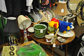
Of course you would find a Jayhawk there! By the way, in case you wonder, the cheer "Rock Chalk" is transposition of chalk rock, the name for limestone found on Mount Oread, site of the Lawrence campus.
What a fun trip back on memory lane!

Wednesday, February 16, 2011

Adventures in Kansas, February; Part 1

We decided this year that each month we would like to take a trip to places we have never been before in Kansas. In January we went to the Museum of National Treasures in Wichita. And this month, we headed out for an overnighter.

First we drove out of Newton onto Highway 50. We spotted this old one-room schoolhouse off the road and had to take a closer look.


The date above the door was 1896. There were 2 out houses, guessing one for boys and one for girls?

Driving on, we knew we wanted to get off Highway 50 at Clements. Clements wasn't on the map but we knew we had seen the sign before and we remembered it being after the town of Florence. It was well-marked and we pulled off at this vanishing town.


Just outside of town there is a native limestone bridge built in 1886; its massive twin arches were quarried from the Cottonwood River. The Kansas Capitol building and several buildings at Fort Leavenworth and Fort Riley and the state reformatory at Hutchinson also are built with this limestone. This bridge is said to be the largest limestone bridge in Kansas.

The bridge is on a road that is now closed but you can drive right up to the bridge . There is a driveway to someone's private property to the right of this dead end. You are allowed to walk on the bridge, but we didn't have snow boots.

To get a good view of the bridge, you need to go back to the new road and continue on. You will pass cows


and horses


then as you look back, you get a good view of the bridge.


We got back onto Highway 50 and pulled off into the little town of Elmdale.


We continued driving through the town on the road (which is also called Old Cowboy Trail). This off-beaten path meanders into Cottonwood Falls.


Cottonwood Falls is the Chase County seat. The courthouse was built back in the 1870's from the native limestone quarried close by. It is the oldest Kansas courthouse that is still in use today.


I really love Cottonwood Falls. I've gone shopping there with my girlfriends. They have great little shops there and a wonderful little cafe!! My husband also took me there on our anniversary one year. We stayed at the Grand Central Hotel. On Friday night, we sat on main street to listen to blue grass music.
Back on the road, this time we drove up 177 on the scenic byway.


The road took us into Council Grove. The city was named after an agreement between the US government and 50 chiefs and warriors of the Osage Nation which allowed settlers' wagon trains to pass through the area and proceed to the West. Pioneers gathered at a grove of trees so that wagons could band together for their trip west.


We stopped for lunch at the Hays House.


The Hays House was built in 1847 by Seth Hays, great-grandson of Daniel Boone and cousin of Kit Carson. He was the first white man to settle in Council Grove. Hays House was used as a trading post, post office, theatre, church, newpaper office and home for US court hearings. In 1857 it was enlarged and became a restaurant and hotel.


Would you believe that Jesse James and Colonel Custer both drank at this bar?


Steps leading to the hotel.


An alligator purse on display. What a fashion statement!!


The original hotel common bath tub.

After a delicious meal including kalua pie (Yum!)we were off again. Once again on 177 but at Alta Vista we turned off onto highway 4 to Eskridge. We had never been on this road before. Very hilly and in the boonies! Such a different experience than Interstate 70!


How would you like a house at the top of this hill? My goodness - can you imagine the view?? And the wind!!

Interesting.
At Eskridge we turned south to highway 31 and on over to 56.

So.....you aren't welcome at any other time??


A train house?
I will post more of our journey another time with our final destination. I must say that I am enjoying these Kansas adventures!